


Manila, June 8 (IANS) A 7.8 magnitude earthquake hit the waters in the southern Philippines on Monday morning, according to the Philippine Institute of Volcanology and Seismology.
The Philippine Institute of Volcanology and Seismology said that the tectonic earthquake occurred at 7:37 a.m. local time at a depth of 33 km, with the epicentre 32 km southwest of the coast of Maasim town in Sarangani Province on Mindanao Island, reports Xinhua news agency.
The institute issued a tsunami warning to nine coastal provinces, strongly advising residents in those areas to immediately evacuate to higher ground or move farther inland following the quake.
It is forecast that the first tsunami waves will arrive on Monday morning and continue for hours.
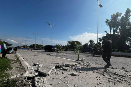
The local media reported that the quake damaged some buildings and caused a power outage. Tremors were felt in neighbouring provinces.
There were no initial reports of significant damage or deaths in either Indonesia or the Philippines, although officials indicated that areas nearest to the epicentre experienced strong tremors.
The quake occurred offshore near Mindanao, the second-largest island in the Philippines, situated in one of the most seismically active areas worldwide, as per local media accounts.
The Philippines experiences frequent seismic activity due to its location along the Pacific “Ring of Fire,” a zone of major tectonic plate boundaries known for earthquakes and volcanic eruptions.
Meanwhile, Indonesia’s Meteorology, Climatology and Geophysics Agency issued a bulletin on Monday morning, launching an early tsunami warning for the coastal areas of northeastern Indonesia following a strong earthquake in the southern Philippines, according to Xinhua news agency.
–IANS
sd/