

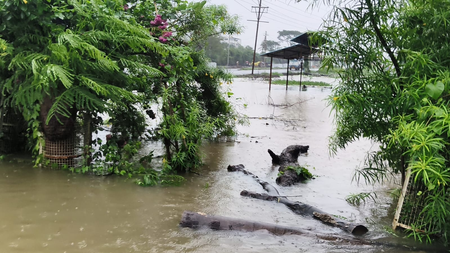
Bhopal, Aug 11 (IANS) Rain showers continued in Bhopal and several other parts of Madhya Pradesh for the third consecutive day on Tuesday, bringing much-needed water but disrupting normal life, with roads and residential areas waterlogged and rivers and streams swelling at several places.
Bhopal received around seven inches of rain in the past 24 hours, according to the India Meteorological Department (IMD), leaving several roads and colonies inundated.
Rainwater also entered houses in low-lying areas. The heavy downpour affected traffic and other daily activities. Schools in Bhopal will remain closed on Tuesday for students from nursery to Class 12 in view of the heavy rainfall.
The district administration has advised people to remain cautious and avoid unnecessary movement in waterlogged areas.
In Sehore, 10 members of a family were stranded in their house near the Bhilakhedi River after the water level rose amid torrential rain. Police, with the help of villagers, rescued all of them on Monday evening.
Raisen also witnessed heavy rain, causing rivers and streams to swell. Rising water levels in the Jakha-Betwa River on Bhopal Road and at Pagneshwar on Sanchi Road submerged small bridges, while water spread into agricultural fields in several areas.
Intermittent rain continued till Tuesday morning. The IMD’s Meteorological Centre has issued a heavy rainfall alert for Neemuch, Mandsaur, Ratlam, Alirajpur, Agar-Malwa, Rajgarh, Guna, Shivpuri, Sheopur and Morena districts for Tuesday.
Light to heavy rain is also likely during the next 24 hours in Bhopal, Raisen, Sehore, Vidisha, Indore, Dhar, Burhanpur, Barwani, Khandwa, Khargone, Jhabua, Ujjain, Shajapur, Dewas, Narmadapuram, Betul, Harda, Gwalior, Datia, Ashoknagar, Bhind, Jabalpur, Katni, Chhindwara, Seoni, Narsinghpur, Balaghat, Mandla, Dindori, Pandhurna, Rewa, Satna, Sidhi, Singrauli, Mauganj, Maihar, Shahdol, Umaria, Anuppur, Sagar, Panna, Damoh, Chhatarpur, Tikamgarh and Niwari.
Weather expert Shailendra Kumar Nayak said a low-pressure area formed over northern Madhya Pradesh and adjoining areas on August 10, with an associated cyclonic circulation extending up to 5.8 km.
The monsoon trough is passing through the centre of the system, resulting in heavy rainfall over parts of the state. He said another cyclonic circulation has developed over the northwestern Bay of Bengal and is likely to lead to the formation of a fresh low-pressure area around August 12.
“The next four days will be crucial for Madhya Pradesh as rainfall activity is likely to continue under the influence of these systems,” Nayak said.
According to the state government’s rainfall data shared at a meeting of ministers and senior officials chaired by Chief Minister Mohan Yadav on Monday, the state received 483 mm rainfall between June 1 and August 10 against the normal 571 mm, a deficit of 15 per cent.
Eastern Madhya Pradesh received 513.20 mm rainfall during the period, while western Madhya Pradesh recorded 459.80 mm.
Around half of the state’s districts have received normal rainfall, while some have recorded deficient rainfall and others are likely to receive more rain in the coming days.
The government has directed officials to closely monitor rainfall, reservoir and river levels and keep disaster control rooms operational in view of the continuing rain.
–IANS
pd/dpb